Diploma in Land Surveying
Fees Structure, Admission, Intake & Deadline
Course Intake
Overview
Programme Objectives
Graduate of Diploma in Land Survey, will achieve the followings objectives:
- Competent, creative, critical and innovative in problem solving related in the field of land surveying.
- Communicate effectively with leadership skill and self-confidence while striving for career development through life-long learning.
- Uphold ethical values and contribute to the needs of the organization and society by participating in various related activities.
PROGRAMME STRUCTURE
- Year 1
Science, Technology and Human, Introductory Academic English, Mathematic for Surveyor 1, Physics for Surveyors, Basic Surveying, Introduction to Geomatics, Computer Aided Design for Surveyors, Appreciation for Ethics and Civilization / Malay Language for Communication 1, Intermediate Academic English, Mathematic for Surveyor 2, Geodesy, Engineering Survey, Field Astronomy
- Year 2
Co-Curriculum and Service Learning, Mathematic for Surveyor 3, Engineering Survey Technology, Cadastral Survey, Computer Programming, Graduate Success Attributes, Geographical Information System, Survey Adjustment, Satellite Positioning, Land Administration, Photogrammetry
- Year 3
Cadastral Practice, Hydrographic Surveying, Cartography, Underground Utility Surveying, Remote Sensing, Survey Camp, Industrial Training, Industrial Training Report
CAREER PROSPECTS
Graduates of the program can work as:
a) Technical assistant for both government sector and private sector.
b) Continue for degree and professional courses to qualify as a Land Licensed Surveyor.
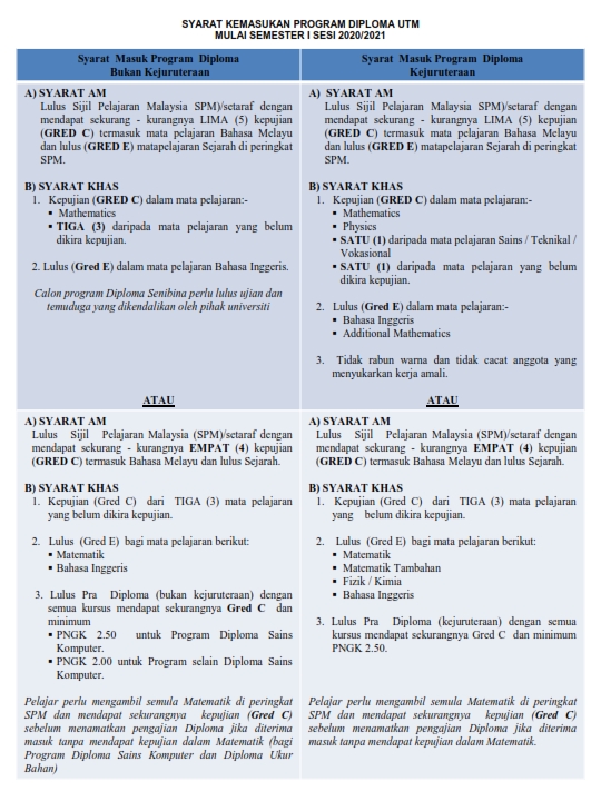
ENTRY REQUIREMENTS